- Home
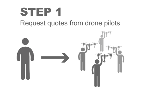
- How it works How it works
-
Drone shop
- All products
- Your shopping cart
- 🔥 Hot-Deals
- DJI Mavic range
- DJI Phantom range
- DJI Matrice range
- Thermal camera drones
- Crop spraying drones
- FPV racing drones
- Underwater drones
- Fishing drones
- DJI Agras (spray drone) parts
- Drone accessories
- Drone Rental
- Drone Repair Services
- About the DFH drone shop
- Stock photos
- Drone Finance - Get Quotes
- Drone Insurance
- Dry Hire Dry Hire
- Industry uses
-
Industry uses
- All Uses
- Construction sites (e.g. fly overs for progress reporting)
- Asset & building inspection (e.g. roof or tower inspection)
- Agriculture (e.g. crop health or spot spraying)
- Environmental survey (e.g. mapping a waterway)
- Mine sites, landfill & quarry (e.g. volume calculations)
- Film industry (e.g. TV commercial)
- Real-estate (includes residential & commercial)
- Events (e.g. festival, corporate event, wedding)
- Small business promotion (e.g. for website & social media)
- Drone light shows
- Case studies
- Weekly news
- Our articles
-
Spray Drones
- Spray drones for sale
- Why the T50 is the best spray drone
- 4 reasons why spray drones are booming
- 5 reasons to consider DFH as your supplier
- 17 reasons to choose a DJI spray drone
- Spray drone case studies & articles
- Image gallery: spray drone demo days
- Mapping drones for sale (regular images & NDVI)
- Thermal drones for sale (animal spotting etc)
- Recommended generators
- Finance providers - get quotes
- Drone Insurance
- CASA requirements for spraying
- T40 Type Rating Certification
- Chemicals license requirements (ChemCert tickets etc)
- Parts store (spray drone parts)
- DFH Batch Master
- Online Training for DJI Agras & M3M
- View upcoming ag. demo days
- DJI Agriculture Authorised Service Center
- Pilots on map
- Pilot list
- Training courses Training courses
- Contact
- Contact
- Pilot Account
- 1300 029 829 All Enquiries
Operators
start here


 April drone sale is currently on,


 Over 15,000 inquiries made & growing
 Over 15,000 inquiries made & growing |


 Spraying & spreading
 Environmental area
 Golf course survey

 Property shots
 Business promo shots

 Film, TVC, or doco
 Events
 Wow factor

 Construction site
 Asset inspection
 Mine, quarry or landfill


 Fast and effective service. Great selection of quotes within a few hours


.png)