Sydney's biggest arts festival is about to turn its lights back on after two years in the dark.
Vivid Sydney, Australia's largest light festival, begins this Friday at dusk.
From projections on the Opera House sails and Circular Quay ferries on the waterfront to mini events and exhibitions throughout the city, for the next 23 days the city will host musicians and artists from around the world.
In spite of two years of Covid-19 cancellations the light show is back for a 12 time with never-seen-before displays.
In a first for the festival of ideas, Sydney will be welcoming a display team of 600 flying drones that are set to illuminate the sky over Sydney Harbour.
Skymagic working with Paramount+ will be delivering the largest drone show ever deployed in Australia. It has taken a lot of coordination.
Chiew Soon Hooi worked with Australia's Civil Aviation Safety to cordon off the aerial display space by Harbour Bridge. However the result will be worth it.
"To have the chance to fly our drone light show offering within such an iconic setting is a real honour," he says.
"Vivid Sydney is an open invitation for Sydneysiders and visitors from Australia and the world to come and experience Sydney at its creative best after dark."
Here's what else to look out for on the Sydney skyline From 27 May to 18 June.
Aussie filmmaker Baz Luhrmann talks Elvis
Headlining the festival of creativity Australian director and King of pop musicals will be talking about his next project: the King of Graceland.
On June 5, as part of the Vivid Ideas programme, he will be introducing a premiere of new film Elvis with a talk at the State Theatre.
The Rocks to Barangaroo
Walsh Bay is between Sydney's newest and oldest post codes. By the Rocks under the Harbour bridge and the newly landscaped Barangaroo Reserve which opened in 2015. The Reserve park holds The Cutaway museum and gallery which is currently hosting the Sydney Biennial.
Light Opera
The Sydney Opera House is New South Wales' natural home of the arts. During Vivid, the sails are transformed into a canvas for projections and film work.
Advertise with NZME.
What happens inside the theatres and performance space inside is equally as eye catching. A bumper programme of artists are booked in to play the famous Aussie venue.
This includes Kiwi artist TEEKS. The Māori soul singer from Tai Tokerau is set to headline Vivid LIVE on June 13.
DJs at the end of the Line
The Goods Line is a revamped freight rail line turned urban walkway. It will be hosting a variety of events over the 23-day festival.
Vivid Sydney is hosting free DJ sets from the likes of Stereogamous and Kate Monroe in the Light Walk at the ends of the Sydney Goods Line. Nightly, from 6pm to 10.30pm. There will be a number of other light installations to explore including the laser installation by Mandylights.
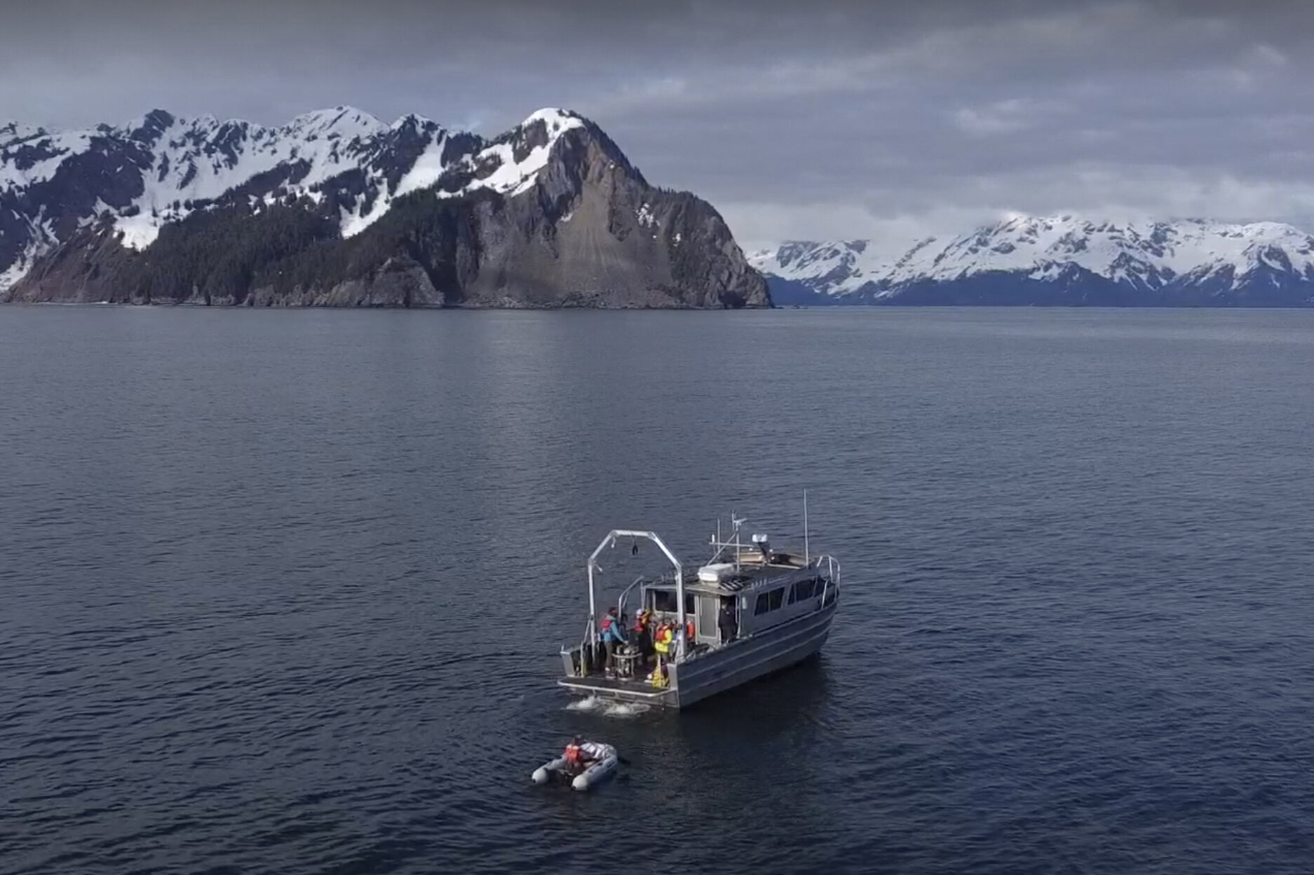
SEWARD, Alaska -- In the cold, choppy waters of Alaska’s Resurrection Bay, all eyes were on the gray water, looking for one thing only.
It wasn’t a spout from humpback whales that power through this scenic fjord, or a sea otter lazing on its back, munching a king crab.
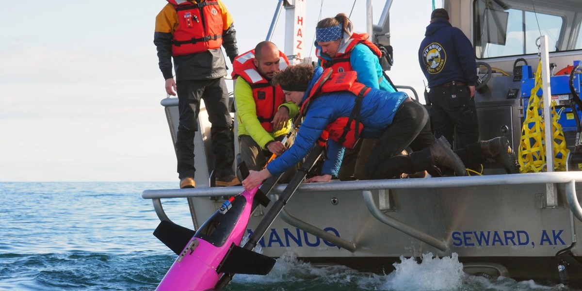
Instead, everyone aboard the Nanuq, a University of Alaska Fairbanks research vessel, was looking where a 5-foot (1.52-meter) long, bright pink underwater sea glider surfaced.
The glider — believed to be the first configured with a large sensor to measure carbon dioxide levels in the ocean — had just completed its first overnight mission.
Designed to dive 3,281 feet (1,000 meters) and roam remote parts of the ocean, the autonomous vehicle was deployed in the Gulf of Alaska this spring to provide a deeper understanding of the ocean’s chemistry in the era of climate change. The research could be a major step forward in ocean greenhouse gas monitoring, because until now, measuring CO2 concentrations — a quantifier of ocean acidification — was mostly done from ships, buoys and moorings tethered to the ocean floor.
“Ocean acidification is a process by which humans are emitting carbon dioxide into the atmosphere through their activities of burning fossil fuels and changing land use,” said Andrew McDonnell, an oceanographer with the College of Fisheries and Ocean Sciences at the University of Alaska Fairbanks
Oceans have done humans a huge favor by taking in some of the C02. Otherwise, there would be much more in the atmosphere, trapping the sun's heat and warming the Earth.
“But the problem is now that the ocean is changing its chemistry because of this uptake,” said Claudine Hauri, an oceanographer with the International Arctic Research Center at the university.
The enormous amount of data collected is being used to study ocean acidification that can harm and kill certain marine life.
Rising acidity of the oceans is affecting some marine organisms that build shells. This process could kill or make an organism more susceptible to predators.
Over several weeks this spring, Hauri and McDonnell, who are married, worked with engineers from Cyprus Subsea Consulting and Services, which provided the underwater glider, and 4H-Jena, a German company that provided the sensor inserted into the drone.
Most days, researchers took the glider farther and farther into Resurrection Bay from the coastal community of Seward to conduct tests.
After its first nighttime mission, a crew member spotted it bobbing in the water, and the Nanuq — the Inupiat word for polar bear — backed up to let people pull the 130-pound (59-kilogram) glider onto the ship. Then the sensor was removed from the drone and rushed into the ship’s cabin to upload its data.
Think of the foot-tall (0.30-meter) sensor with a diameter of 6 inches (15.24 centimeters) as a laboratory in a tube, with pumps, valves and membranes moving to separate the gas from seawater. It analyzes CO2 and it logs and stores the data inside a temperature-controlled system. Many of these sensor components use battery power.
Since it's the industry standard, the sensor is the same as found on any ship or lab working with CO2 measurements.
Hauri said using this was “a huge step to be able to accommodate such a big and power hungry sensor, so that’s special about this project.”
“I think she is one of the first persons to actually utilize (gliders) to measure CO2 directly, so that’s very, very exciting," said Richard Feely, the National Oceanic and Atmospheric Administration's senior scientist at the agency's Pacific Marine Environmental Laboratory in Seattle. He said Hauri was a graduate student in 2007 when she accompanied him on the first acidification cruise he ever led.
The challenge, Feely said, is to make the measurements on a glider with the same degree of accuracy and precision as tests on board ships.
“We need to get confidence in our measurements and confidence in our models if we are going to make important scientific statements about how the oceans are changing over time and how it’s going to impact our important economic systems that are dependent on the food from the sea," he said, noting that acidification impacts are already seen in the Pacific Northwest on oysters, Dungeness crabs and other species.
Researchers in Canada had previously attached a smaller, prototype CO2 sensor to an underwater drone in the Labrador Sea but found it did not yet meet the targets for ocean acidification observations.
“The tests showed that the glider sensor worked in a remote-harsh environment but needed more development,” Nicolai von Oppeln-Bronikowski, the Glider Program Manager with the Ocean Frontier Institute at Memorial University of Newfoundland, said in an email.
The two teams are “just using two different types of sensors to solve the same issue, and it’s always good to have two different options,” Hauri said.
There is no GPS unit inside the underwater autonomous drone. Instead, after being programmed, it heads out on its own to cruise the ocean according to the navigation directions — knowing how far to go down in the water column, when to sample, and when to surface and send a locator signal so it can be retrieved.
As the drone tests were underway, the U.S. research vessel Sikuliaq, owned by the National Science Foundation and operated by the university, conducted its own two-week mission in the gulf to take carbon and pH samples as part of ongoing work each spring, summer and fall.
Those methods are limited to collecting samples from a fixed point while the glider will be able to roam all over the ocean and provide researchers with a wealth of data on the ocean's chemical makeup.
The vision is to one day have a fleet of robotic gliders operating in oceans across the globe, providing a real-time glimpse of current conditions and a way to better predict the future.
“We can ... understand much more about what’s going on in the ocean than we have been before,” McDonnell said.
New drone technology is allowing mountain rescue teams to dramatically improve how they search for people who get stuck and stranded on Britain's highest peaks.
As well as using drone cameras to find the climbers, the drones can now be fitted with lights and loudspeakers to help communicate with those who are trapped.
The new technology has been developing over several years but is now being used in active rescues.
Volunteers from Lochaber Mountain Rescue Team and Cairngorm Mountain Rescue Team showed BBC News how it all works.
For 17 years a Perth council has been fighting a losing battle against hordes of mosquitoes breeding in urban wetlands.
For 20-year resident David Crispin, it cannot come soon enough.
"Some years you'd go for a walk around the paths, and they'd just be attacking you in swarms," he said.
"Sitting out on the balcony, you'd be swatting them away and they would certainly come in [the house]."
Among Australia's first
In a trial already underway, the City of Bayswater has become one of Australia's first local governments to use drones to spray mosquito larvae in areas that are otherwise difficult for its workers to reach.
Mosquito Control officer Don Sorensen said staff had previously tried to spray mosquito larvae in the Berringa wetlands by foot, "but we just sink in the mud and lose our wellies".
"Sometimes you're up to your waist in mud so it's quite dangerous.
"Also, these wetlands are where our tiger snakes and our dugites live."
He said the council had also tried using a six-wheeled amphibious vehicle to traverse the wetlands, but it would become bogged in heavy mud.
"We had to leave it for a while — until we started researching the drones," Mr Sorensen said.
Stocked with larvicide
Multiple drones weighing up to 67 kilograms have been fitted with 30-litre tanks of a biological larvicide, which specifically targeted mosquitoes.
The naturally occurring soil bacterium was only toxic to mosquito larvae and did not harm surrounding wildlife or vegetation.
The drones are controlled by certified drone pilots, who are notified by a safety spotter on the nearby Swan River about any changes in weather or if there is a nearby kayaker or fisher.
Mr Sorenson said the wetlands had provided excellent mosquito breeding conditions for the past couple of years.
"We've been in a second year of La Niña, which is creating huge tides in all the rivers coming up the rivers around Australia, including the Swan River," he said.
He said the council planned to treat about six hectares of wetlands using drones over the peak mosquito season from December through to April.
On high alert
But the mosquitoes were more than just annoying pests.
Mr Sorenson said there was an ever-present potential for mosquito-borne diseases like Ross River virus and Barmah Forest virus in the City of Bayswater and surrounding local government areas.
Mosquitoes in Western Australia could also transmit Kunjin virus and the potentially fatal Murray Valley encephalitis virus.
WA Health senior scientific officer Dr Jay Nicholson said data showed the number of Ross River virus cases in the Perth metropolitan area had increased since January, although he did not provide figures.
"This [increase] is consistent with the five-year average," he said.
"Given January-March is peak mosquito season in the metro area, this is not surprising and we would expect the cases to reduce as we move into the cooler months."
WA authorities were also on high alert for any cases of the Japanese encephalitis virus, which had been recorded in Queensland, New South Wales, Victoria and South Australia this year, although there had been no cases recorded in WA.
Strict guidelines in place
Chris Sieber, owner of Omnidrone, the company contracted to carry out Bayswater's mosquito-busting operation, said mosquito mitigation was a "unique" way to use drone technology.
"This technology is still very new in the industry," he said.
"A lot of the capabilities of drones — and also the limitations — are not completely known."
He said it had been two years in the making due to strict regulations involving drones in populated areas.
"We have had to put safety plans together, procedures to fulfil the requirements of the Civil Aviation Safety Authority (CASA)," Mr Sieber said.
City of Bayswater Mayor Filomena Piffaretti said the council also worked with WA's Department of Health and neighbouring local governments to monitor and combat mosquito-borne diseases in the eastern portion of the Swan River.
"We share the responsibility of managing the mosquito issue with other local governments along the Swan River and several other councils have already expressed an interest in our [drone] trial," she said.
Do you love drones too? Join us - turn your passion into a career!
Drones for Hire is looking for a full time (4 or 5 days/wk), staff member to join our small and growing team! You will be helping across many aspects of our business, with a central focus on managing the customer experience.
5 days/week, 3 days from our office in Lindfield, 2 days from home. Flexible to do variations of this.
You may be someone already in the drones industry who is looking for a secure full time position OR someone with a passion for drone tech and wanting to join a team of like minded people.
love drone tech (bit of a tech geek like us)
Super clear and professional communication skills
highly disciplined and dependable in how you work (manage checklists and routines etc)
Some key tasks:
Taking inbound inquiries (answering the phone, company emails, job inquiries, chatbot messaging)
understanding each customer’s needs such as help post their quote request or help advise which drone to purchase
Order fulfilment process (sourcing, shipping, maintain the customer experience)
Assist with marketing activities such as prepare promo emails
Do drone demonstrations and learn more about the technical side of drones as you go
Must be self-motivated and keen to engross themselves in the business. We are looking for someone to stay and grow into a general manager role. In your reply, you may like to comment on this 2-min video https://youtu.be/fj0hpsJvrko
We are very honored that our M2 ROV could work with the underwater training institute Survival Systems USA to provide support in their training for NASA( National Aeronautics and Space Administration). They have simulated a vacuum underwater to train astronauts and used our M2 ROV to record footage of young astronauts coming out of the cabin.
This kind of training could help astronaut researchers in becoming familiar with the feeling of weightlessness that they will experience in space. The video has captured just how intense astronaut research training can be.
Some photos are for your reference.
22 March 2022
In March 2022, a drone school in Japan took our underwater drone M2 to the bay of Wakayama Prefecture to investigate the growth of local characteristic algae. We are delighted that M2 will play an increasing role in marine environmental investigations.
This video is very well shot, please kindly enjoy the underwater beauty.
01 March 2022
Recently, the automatic cage detection function in CHASING APP has been updated.
This function is mainly for customers in the aquaculture industry and is suitable for round and square cages.
When the CHASING M2 ROV/M2 Pro ROV is equipped with the distance lock sonar, the automatic cage detection function can be turned on on the APP, which can realize the separation from human control. The ROV automatically detects the entire cage, allowing the operator to complete the inspection network faster and more effectively.
The following is the guide video of the APP interface for your reference:
20 Jan 2022
Recently, Toyama School, an underwater drone school in Japan, invited the famous announcer of NHK Company in Japan, to cooperate in the shooting, challenging the use of underwater drones for fishing shooting.
A Japanese distributor, Spaceone, will open the Air Ocean Drone School Tokyo School in Tokyo in March, based on the rich achievements and experience accumulated in the Fukushima Drone School. A variety of drones in the air and underwater will be exhibited here. In addition to providing various drone pilot certification courses, the opening of underwater drone safety diving pilot training courses will also expand the use of underwater drones in the industry, more training activities can be conducted for local fire departments, fire brigades and industry customers.
15 Jan 2022
Australian distributor PESAC recently used the Chasing M2 ROV in combination with an auxiliary camera for underwater inspections.
The auxiliary camera is an exclusive accessory developed for Chasing M2 Pro ROV. Used with CHASING GO1 App, it allows users to engage in real-time viewing and shooting via their mobile device, and supports both photography and video functions. And it provides additional viewing angles to facilitate underwater operations, and can capture multi-view data at the same location, reducing ROV operations, especially suitable for hull maintenance and inspection, providing hull industry customers with the best solution.
Click the link below to watch the detailed video:
14 Jan 2022
Recently, a Hong Kong dealer used Chasing M2 ROV in combination with DJI drones to inspect ships at the dock.
The underwater robot navigates around the hull by the operation of the remote, delivering high-definition video footage and images of the hull in real-time for the captain to evaluate.
Such hull inspections greatly simplify the process and make hull inspections more frequent and less expensive. Since no diver is required, there is no need to shut down the vessel's systems for inspection.
Using underwater robots, daily and continuous hull condition monitoring can be performed during daily docking, enabling shipowners and operators to implement appropriate maintenance plans to optimize vessel performance.
Click the link below to watch the detailed video:
11 Jan 2022
In recent years, more and more countries have paid attention to biological invasion in port. On the night of January 7th, in Port Stavanger from Norway, M2 & M2PRO were used in mapping the prevalence of "sea vomit"(Didemnum vexillum) on the seabed.
Sea vomit is an invasive species in Norway and was first discovered here in Stavanger one year ago. The sea vomit has no known predators in Norway and can make big damage to local marine life. This species can grow colonies up to 11 times bigger every 14 days and can cover big areas where all other marine life will die.
Nowadays CHASING M2 and M2 Pro underwater drones are used in a project to find ways to limit and reduce the spread of these colonies. This is not a problem only in Norway, this species has spread to New Zealand, the USA, Canada, and Europe, bringing a big problem for the marine life there.
Recently, Chasing ROVs are being used in conjunction with PIX4D to provide a comprehensive inspection of infrastructure including dams and bridges, and it has helped the operator to be more prepared to understand the distribution and dynamics of the underwater target area.
How it works: Use Chasing M2 and Pix4D Mapper to perform underwater photogrammetry, drive M2 to shoot and upload the target area and objects from multiple angles, and use PIX4D to model the actual image through three-dimensional technology, magnify the situation of each point, and get the underwater clearly The three-dimensional structure environment.
Please kindly check the actual case video of a Norwegian customer using Chasing M2 and Pix4D Mapper to do underwater photogrammetry.
10 Dec 2021
Yesterday, M2Pro helped ship owners in Kyongpohae, South Korea, inspect propellers and anchor chains. "It's so convenient, commonly, without entering the dock, we had to employ divers to check the situation. Now with the M2Pro we can easily inspect the fleet by ourselves, with distance lock sonar, we guys can learn to use very is such quickly, which is very convenient, "the shipowner said excitedly.
Helsel, the Korean distributor of CHASING, received a call from Goyang Police station, hoping to find the missing persons at the southern end of the Gyeongpo Bridge with the help of CHASING M2/CHASING M2 Pro. The man went missing near the Kimpo Bridge. His jumper was found on the banks of the Han River two weeks after he went missing. Police are focusing their search on missing people based on where the clothing was found.
At first, CHASING M2 was put into use, but over time it became too strong to move forward due to the inflow of water from the West Sea.
Later, it was replaced with M2 PRO, a higher version of the product with higher motor power and 4 knots of anti-current. After changing into CHASING M2 PRO, the police overcame the current and continued the search. CHASING M2 PRO made 2-3 searches in the vicinity of the underwater beam from the expected missing position to 200m ahead and helped them to judge the places effectively.
Besides, CHASING has introduced USBL and BP image sonars, which are very helpful for underwater search and rescue. In the future, CHASING ROVs will continue to assist search and rescue teams and police departments in searching for missing and drowning people.
26 Nov 2021
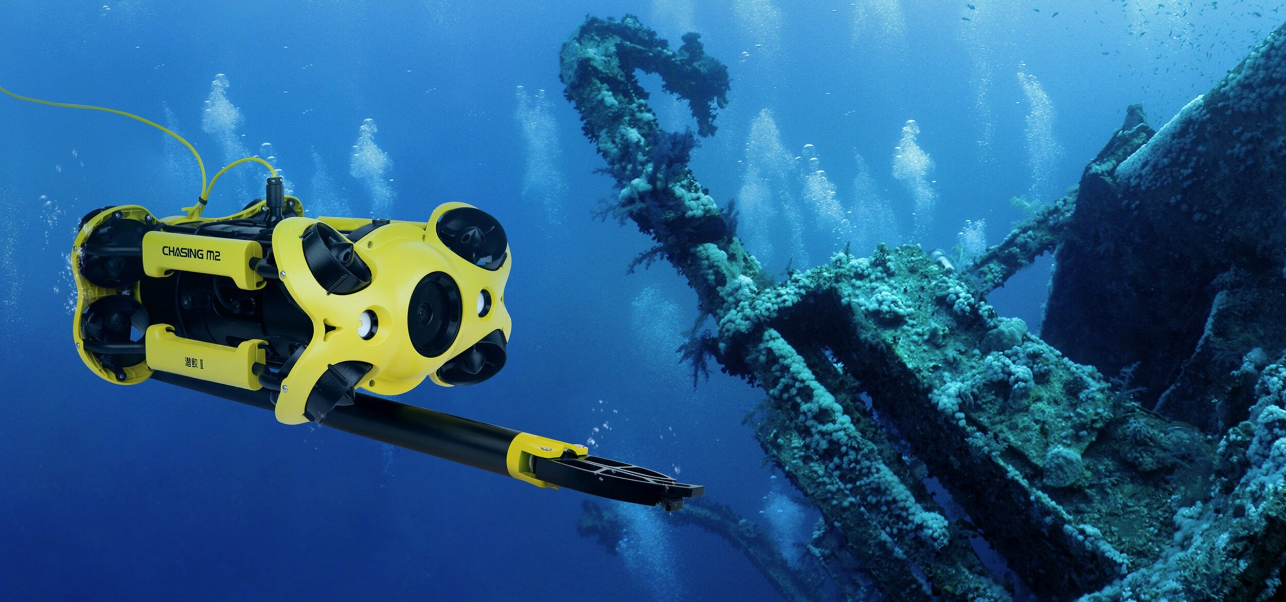
9News, one of Australia's most-watched news services, has just broadcasted news reports about marine life in Australian waterways captured by our M2 drone.
The underwater ROVs or drones can double as a dive buddy, scanning for information in marine settings and carrying out vital inspections on pipes, hulls, and water tanks.
Besides, Chasing ROVs can be fitted with a range of sensors and accessories such as gripper arms, sonars for low visibility inspections and search and rescue, water sampling, and scientific payloads.
The drones can be lowered to 150 meters beneath the surface.
Remotely operated vehicles are increasingly being used in Australia and global markets. Check the link below for details:
I'd like to share the latest video shared by Cape Fear Explorers, the non-profit dedicated to the efforts of finding and preserving historic artefacts located in North Carolina, USA.
The Chasing M2 with the grabber arm has helped divers to find a crashed airplane underwater, providing an extra security guarantee underwater as well as helping dives better communicate about the mission at hand. They are impressed with the equipment as it has helped them to check out sites without disturbing them. They will continue to use this technology for surveying and monitoring sites underwater. Check out the details:
Recently, A fishing farm in Chile used Chasing M2 ROV to salvage dead fish and has shared the inspection video with us.
Chile, by virtue of its geographical location, provides conditions for salmon farming, but its own high levels of SRS bacteria and the destruction of cages by aquatic organisms make it necessary for fisheries customers to use ROV for real-time dead fish clean-up and cage testing every day.
29 Oct 2021
The Blue Sky Rescue Team uses CHASING M2 PRO to help salvage those who fell into the water. It is quickly deployed, convenient and efficient, and quickly locates the position of those who fall into the water.
A Norwegian fishery uses CHASING M2 PRO to assist in the cultivation of mussels, Quick deployment, convenience, and high efficiency, successfully reduce breeding costs and promote marine environmental protection.
25 Oct 2021
On October 15th, Сергей Сорокин from Russia(with 219,000 subscribers) took Chasing F1 to the beautiful lake and filmed a fishing test video which showed F1 performed excellently in fishing and also increased the interest in fishing.
This is the second Chasing F1 video released by our KOL Сергей Сорокин, who has great influence in the fishing circle in Russia. This time the theme of the video is to use F1 to find carp, focusing on the entertainment of the fisherman’s life. The footage produced by this KOL is very good. Since its release on October 19th, the video has been viewed more than 10,000 times, more than 1,000 likes, and more than 300 comments. The original materials used by KOL have been given to our marketing department for video clips, and related videos in English will be output later.
19 Oct 2021
Here are the solution documents for three major industry applications:
From April 2021 to the present, a shipowner in Singapore used M2 PRO to conduct underwater inspections for ships. Shipowners will regularly use ROV to collect videos and photos to determine the corrosion of the hull and the attachment of marine organisms to investigate potential safety hazards. Through the lens of the M2 PRO, the underwater hull, the side plates, welds, and valves are visible in real-time clearly. Even in dim waters and narrow spaces, the details of the hull can be easily observed. While the data detected by the M2 PRO provides an effective basis for the hull cleaning plan, it also greatly reduces the high labor costs of using divers for ship inspections and reduces safety hazards.
Youtube video link below:
14 Oct 2021
On September 21st, KOL Dustin Dunnill from the United States (with 246K subscribers) shared a CHASING M2 Underwater Drone ROV Dive Test Review. The video was viewed 26,164 times, making the public realize how useful this highly portable ROV is.
12 Oct 2021
Our Australian partner Spot X has just made an introduction video for operating the latest function of the Hull inspection tool/report generator in the Chasing ROV app G01.
This function allows you to efficiently conduct a hull inspection and generate a report.
With this feature, you could choose the pictures which are to be shown in the report. Sometimes, you may have to cancel few pictures because of poor quality or wrong angle or some obstruction.
You could mark the specific hull location when you take close-up pictures of certain niche areas – such as under bilge keels, propeller boss, rudder pintle bearing area, inside of sea chests, etc.
This feature makes it easier for you to manoeuvre to ROV models more efficiently to get the report.
Click the following link to see the introduction video.
21 Sept 2021
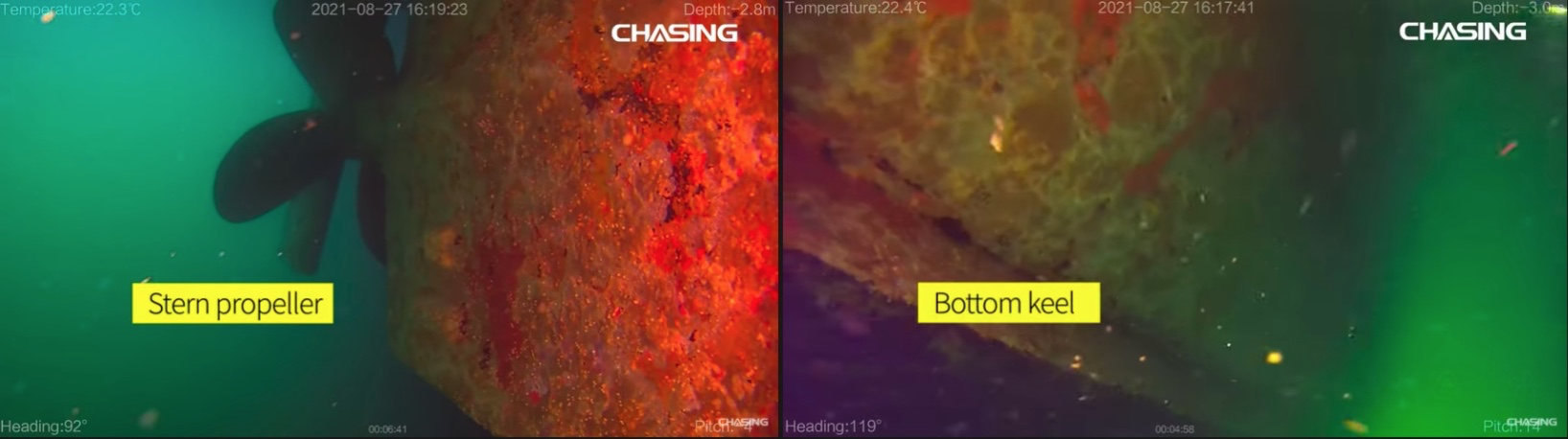
The Ukrainian Seaport Authority uses CHASING M2 for hull inspection, including propeller, hull sides panels, bottom keel, and stern propeller etc.
CHASING M2/M2 PRO Underwater Drone is good for hull inspection, which can do 80% of the entire hull inspection job, such as Hull videography and photography, the bilge keels, propeller, rudder, bow thrusters, transducers, cathodic protection. The underwater drone helps lower the hull inspection project costs, since diver do only the remainder 20% areas where ROV cannot access.
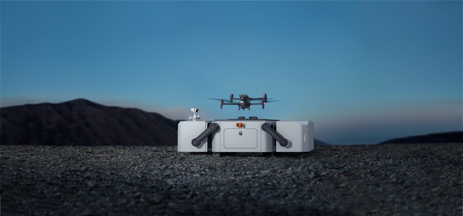
DJI has introduced their next generation of enterprise solutions. At a launch event today, the drone industry was introduced to a new drone from DJI and a suite of new enterprise products: the Matrice 30 Enterprise, along with the DJI Dock for remote operations, a new RC controller, and the new Zenmuse H20N sensor, giving “starlight vision” to the DJI M300 RTK drone.
DJI calls the new products “an all-in-one solution for professional drone operators” combining a sophisticated, cutting edge aircraft with a “fully remote fleet management system and an autonomous docking and recharging station.
This integrated solution unlocks powerful new functionality for Enterprise drone users such as public safety agencies, infrastructure inspectors and energy operators, allowing them to build next-generation operations that finally unlock the full potential of DJI’s transformative technology.”
The new drone from DJI enters the “drone-in-a-box” field, allowing totally remote operations – critical as a ruling on BVLOS flight gets closer in the US and around the world.
“DJI Enterprise is devoted to researching and developing new drone solutions explicitly designed to revolutionize work, helping everyday heroes in their missions saving lives, maintaining physical infrastructure, and preserving the natural environment. With the outstanding performance, transportability and ease of use of the DJI Matrice 30 drone and its perfect integration with the DJI FlightHub 2 Fleet Management Cloud Software and DJI Dock, DJI is stepping into the future for our Enterprise customers who will be able to enter the autonomous solutions space, creating possibilities to fly beyond visual line of sight with the appropriate regulatory permissions in place,” said Christina Zhang, Senior Director, Corporate Strategy at DJI. “We are proud to deliver the next generation of aerial tools that will save lives and bring work to new heights, with a 360-degree product solution suite for a variety of fields such as energy inspection, emergency rescue missions, environmental protection, and the digitization and preservation of cultural heritage.”
The new DJI Matrice 30 fits in a backpack, integrates multiple high-performance sensors into one single camera payload, is controlled with an ingenious redesigned remote control and runs on upgraded Pilot 2 software. “The M30 model offers much more power, endurance and capability for rugged professional uses, while its size makes it ideal for easy transportation and fast setup.”
The DJI Dock is a game-changing development for DJI, putting them into the arena for fully remote operations. This is a highly valuable set of applications, enabling security and inspection missions on remote sites: but these applications require a secure, weather-proof system as well as sophisticated software. With the M30, DJI will compete against Israeli company Percepto and other drone-in-a-box solutions currently used for industrial inspections.
With IP55 ingress protection, the M30 offers outstanding performance in harsh environments, in heavy rains, high winds, high altitudes, even in icy and snowy conditions and extreme temperatures from -20° C to 50° C.
The DJI M30 also offers an improved first-person view pilot camera for low light conditions, built- in redundancies and backup systems, three-propeller emergency landing, a Health Management System, and six-way obstacle avoidance sensors enabling the pilot to focus on the mission. Its four-antenna OcuSync 3 Enterprise transmission ensures a strong redundancy, and it supports LTE link backup2, in the face of complex terrain and working conditions.
Unlike other commercial drones, the DJI M30 adopts a foldable integrated lightweight design (3.7 kg take-off weight) that is easy to unfold, store and carry anywhere. Its new self-heating TB30 battery design can support at least 400 charge cycles and allows a 41-minute flight time. Its smart BS30 charging case allows quick battery charging from 20% to 90% in 30 minutes. The M30 also has a new self-locking system and can be folded by just pressing a button. This makes it the fastest, easiest high-performance DJI Enterprise drone to set up.
The DJI RC Plus, the new Flagship Enterprise remote controller.
The new DJI RC Plus remote controller meets the high expectations of professional pilots. The DJI RC Plus features a 7-inch-wide high-definition screen enabling pilots to see more visual information thanks to an impressive brightness. As the DJI RC Plus is IP54 certified, similar to the M30 drone, it can be used in heavy rain.
The DJI RC Plus has six physical buttons below the control sticks next to the screen. They make piloting much easier, giving control of mission-critical functions, like switching between wide angle, zoom, infrared, and FPV views, without having to take hands away from the control sticks.
The RC has 6 hours of screen-on time. It has an internal battery and a swappable external battery, preventing the interruption of a mission. The DJI RC Plus offers ports for microSD card, USB, HDMI, USB type C and 4G connectivity (where offered)3, for customers needing transmission redundancy.
The DJI RC Plus naturally becomes the new DJI flagship Enterprise remote controller4.
The DJI FlightHub 2 is DJI Enterprise’s fleet management software. It benefits from major improvements from its first version synchronizing and coordinating between ground teams at work, drones, payloads, pilots and all the data they gather. The DJI FlightHub 2 is now entirely cloud based. It enables flight mission management and operational viewing not only from the pilot’s RC, but from any device with a web browser, such as computers, tablets, and evenmobile devices. Now, everyone involved in a drone operation, from ground teams to nearby supervisors to managers in their offices, can log into the same mission and see the data gathered by the drones and the pilots.
The DJI FlightHub 2 supports mapping features enabling users to respond quickly to developing situations.
● One-Tap Panorama Sync creates a 360° overview and uploads to the cloud with a single tap. Shared panoramas, and the coordinates they were captured from, are placed on your mission’s 2.5D Base Map, granting all team members quick aerial awareness.
● Cloud Mapping lets users highlight an area of interest, enabling the DJI M30 to automatically map the area in 2D, offering great perspectives during emergency response planning situations. DJI FlightHub 2 will turn these images into a map, which will overlay on the user’s map service provider. Once a map is captured, it can become the base to build a mission plan around.
The DJI FlightHub 2 supports Live Annotations, which are points, lines, or polygons that users can draw on the map. Thanks to the laser rangefinder of the DJI M30, in a search and rescue mission, a pilot can pinpoint the coordinates of a missing person. These coordinates will automatically sync through the DJI FlightHub 2 mission interface allowing the command center and the team on the ground to have live updates of coordinates and to simultaneously generate rescue routes. All these maps, models and inspection data can be uploaded to the cloud, supported by AWS, and accessed and managed remotely.
DJI FlightHub 2 becomes must-have software to streamline communication between the command room and the team on ground, and manage real-time missions.
DJI Dock: Autonomous Docking For Programmed Flights in Remote Areas
The DJI Dock is an autonomous takeoff, landing and charging station allowing fully automatic, programmed flights with the DJI M30 Series (Dock Version). It widens the horizon for automated missions that can be monitored and supervised remotely. After setup, the fully charged M30 drone can take off to the skies from the DJI Dock through FlightHub 2 programmed automatic missions anywhere within a 7 km radius.
Fast Rotation Operation – Once the drone lands after its mission, it will recharge automatically. Thanks to the fast charging and battery cooling system, the drone can take off again only 25 minutes after it landed.
Excellent environmental adaptability: Its modular durable design allows continuous operations day and night, no matter what the weather is. The DJI Dock was built to last, and to require minimal care and maintenance. The Dock is rated at IP55 and the core internal components are IP67, making it waterproof and dustproof even when it is open. The DJI Dock’s interior is climate controlled, to help bring the batteries to the optimal temperature for charging M30 safely even with external temperatures ranging from -35 to 50 degrees Celsius.
Its connectivity can be expanded, thanks to a port for an external 4G dongle5. In case of power outage caused by a disaster, an internal battery will take over and keep the Dock operational, to make sure the M30 lands safely from its mission.
Easy to set up, easy to deploy: The DJI Dock only weighs 90 kg and covers an area of less than 1 square meter, and can be transported by elevator; it only needs to be fixed on the ground, turned on, connected to the power supply, and connected to the internet. The DJI Dock integrates built-in antennas, a weather station, ultra-wide-angle surveillance cameras and a D- RTK base station. The installation is in one step, and the integrated design greatly reduces the difficulty of deployment.
The DJI Dock is also extremely easy and practical to set up and configure. It can be done directly on site with the DJI RC Plus offering complete control over the Dock and the M30, the missions and its scheduling, as well as the data collected.
Ready for advanced regulations: The DJI Dock opens new possibilities for many fields that can benefit from automated flights, such as infrastructure inspection, site monitoring and engineering supervision. In areas where drones are allowed to fly autonomously, unattended or beyond the operator’s visual line of sight, the DJI Dock is ready to enable those operations, with remote supervision from another location through FlightHub 26.
Michael Bay’s latest movie, Ambulance, will hit the theaters on April 8. Ahead of the release, a new behind-the-scenes video has dropped this week, showing how the director used FPV drones to pull off some absolutely spectacular shots in the pulse-pounding heist thriller.
Based on a 2005 Danish film of the same name, Ambulance tells the story of two bank robbers who hijack an ambulance occupied by a paramedic and a patient in critical condition. In keeping with Bay’s signature style, the action sequences are extremely fast-paced. And what better than a small FPV drone to get right in the middle of the action and capture shots that otherwise wouldn’t have been possible?!
Bay’s fascination for the best, most innovative camera technology is no secret. Producer Michael Kase, who’s done nine movies with Bay to date, says one of his first jobs on every production is to find the “newest, coolest gear out there.” On this one, it’s FPV drones.
And to capture the high-octane drone shots, Bay roped in Alex Vanover – one of the fastest, most aggressive, full-throttle drone racing pilots who won the 2019 DRL World Championship at the age of 19! The Dallas lad says:
When I’m flying the drone, I’m acting like Superman, in a way. I’m trying to get these really unique angles and shots. I fly what’s called an FPV drone, and FPV stands for first-person view. We wear a set of goggles on our face, and when I’m flying the drone, I’m actually flying it with a VR headset. I’m able to see exactly what the drone’s seeing in real-time. So, it’s a whole new arena for flying, and it allows us to fly really crazy locations and get some really awesome shots that you can’t get with any other camera or drone.
Biological science students at Cal Poly in San Luis Obispo have schooled themselves in the art of drone piloting as part of their noble pursuit of counting members of local elephant seal populations.
The group of professors, graduate, and undergrad students at Central California’s Cal Poly are deploying their drones above seven different regional beaches to take an improved gander at residing elephant seals. A main objective in the Vertebrate Integrative Physiology’s Lab and Field effort will be to get an accurate count of the pinnipeds, which can amass in preferred spots from anywhere from 200 to over 1,000 individuals. Those census missions will be flown while the creatures are ashore for their mating season, which will wind up later this month.
Once the post-amorous elephant seals clear out and back to sea, the group will study the (possibly X-rated) photographs captured by the drones to get a fix on their numbers. Those may also offer an idea on how the sizes of groups fluctuated over the length of the mating season.
Though the annual counting project has existed since 2017, this is the first time the Cal Poly students will be turning to UAVs to facilitate the task. In addition to producing more precise numbers than previous eyeballing methods, the aerial technique is also less intrusive, and therefore less likely to provoke reaction from the mammals that human presence can. (With the weighing and tagging of seal new seal pups also part of the study, however, that decreased invasiveness of aerial tech will eventually become a mooted advantage.)
Volunteers to the project have nearly doubled in size from the original 30, with this year requiring some member to go to school on drone piloting before deploying the craft above elephant seal communities.
Because the flights are part of a formal venture, students had to study and pass Federal Aviation Administration Part 107 certification. They then had to demonstrate to State Park authorities that both they and their drones were safe and reliable to fly above unsuspecting elephant seals. They then had to obtain permits to operate in restricted state coastal and Cal Poly airspaces (including an area intriguingly known as “the beef unit”).
Readers in the area interested in checking out the group’s work may catch them taking tallies of seals below along the coastal strip known as Piedras Blancas, about five miles north of Hearst Castle.
DJI Mini 3, the highly anticipated successor to the popular Mini 2 drone, has been dominating the rumor mill as it approaches a supposed release date of April 2022. In the latest development, a DJI leaker has released a list of possible specs the upcoming drone could feature.
According to the new rumored specs list, the DJI Mini 3 drone could sport:
A 1/1.3-inch CMOS sensor
F1.7 large aperture
A gimbal tilted at a large angle allowing you to shoot upwards
A camera supporting vertical mode
3-directional obstacle avoidance
ActiveTrack Mode
O3 transmission system
A new remote controller with built-in screen
For comparison, the Mini 2 comes with a 1/2.3-inch CMOS sensor to deliver 12MP stills. It uses the less advanced O2 transmission system, and doesn’t feature any obstacle avoidance sensors. The sub-250-gram also doesn’t support subject tracking natively. But with the recent release of Mini 2 SDK, third-party flight apps such as Litchi have begun to offer tracking and “follow me” modes to Mini 2 users.
In any case, the Mini 2, which was released in November 2020, is long due for an overhaul. Previous rumors have indicated that the revamped drone could feature a new aerodynamic design with a carbon-fiber body. Expect to see downward slanted arms, larger propellers, as well as forward, backward, and downward obstacle avoidance sensors. The maximum flight time is also expected to increase with possibly a battery extender. And the drone camera will, no doubt, see an improvement.
It’s worth highlighting that with the recent arrival of Autel Nano and Nano+, DJI finally has some serious competition in the sub-250-gram space. However, with the Nano’s standard package costing at least $200 more than the Mini 2, DJI still has a significant edge in a budget-conscious market. And to retain that edge, the new and improved Mini 3 will also need to come at a competitive price.

/cloudfront-ap-southeast-2.images.arcpublishing.com/nzme/K55L36TEDGICDLNGV6O6DSYHZY.jpg)
/cloudfront-ap-southeast-2.images.arcpublishing.com/nzme/MMAHD5JZFTIQ5PCC3QXANIPXVA.jpg)
/cloudfront-ap-southeast-2.images.arcpublishing.com/nzme/XETTO5OMZIZQK2RFJFGTJT5YHA.jpg)