Continuing a trend that we’re seeing across camera sectors in film and video, DJI is doubling down on its entry-level and prosumer models with the announcement of the DJI Mini 4 Pro, and the upgrade on the DJI Mini 3 Pro, the company’s current popular starter drone-camera selection.
Boasting new omnidirectional obstacle sensing and all around upgraded features both for beginners and more advanced flying shooters, the DJI Mini 4 Pro promises to still keep its super lightweight flyability, but with improved 4K video which can record up to 100p high-speed recording for those beautiful slow motion aerial shots.
Let’s take a look at the new DJI MIni 4 Pro and explore how it stacks up to its predecessor, and if it ultimately might be a good starter drone for you and your aerial videography needs.
Introducing the DJI Mini 4 Pro
Designed to be the “ultimate mini camera drone,” DJI has chosen to update its popular DJI Mini 3 Pro with a respectable amount of new specs and features. Yet, this isn’t a complete redesign.
The Mini 4 Pro will include the same sensor as its predecessor. But as a 48 megapixel CMOS sensor, plus combined with a new image-processing platform, it should get the most out of its 24mm-equivalent f/1.7 lens and its 82.1-degree field of view.
So, the top spec for the Mini 4 Pro is going to be its 4K at 60p HDR video, plus some impressive slow-mo recording capability at 4K up to 100 fps as well. The Mini 4 Pro should also boast some enhanced noise reduction algorithm stats for its NIght Shots mode, as well as a True Vertical Shooting mode specially optimized for social media and smartphone video footage.
Lightweight and Under the Radar
Still, while the sensor and video stats should satisfy most online video needs, the real calling card for the DJI Mini 4 Pro (like its predecessor) is its super lightweight design and ease-of-use. Weighting in at just under 250 grams (8.8 ounces), the DJI Mini 4 Pro does not need to be registered to fly with the Federal Aviation Administration (FAA) in the United States since it’s 1g below the required weight threshold.
The DJI Mini 4 Pro also boasts some notable maneuverability improvements and safety features including upgraded omnidirectional obstacle sensing (and improvement over the Mini 3 Pro’s tri-directional sensing).
The Mini 4 Pro should also include updated obstruction detection from all directions now with its multiple wide-angle and downward-facing vision sensors.
With a flight time up to 34 minutes at launch (without extra accessories), which is pushable further with the Intelligent Battery Plus package, it should stay in the air about as long as its predecessor.
Overall, the DJI Mini 4 Pro isn’t a complete reinvention of the wheel here, but it’s a serviceable upgrade of a popular entry-level drone camera system that should be great for beginners or hobbyists looking for a new weekend pastime.
With its 4K video and slow-mo recording options, it shouldn’t be too hard to get your hands wet with some beautiful cinematic footage too as you hone your skills and perhaps upgrade to a higher-end drone camera system later.
The Los Angeles Lakers enter the 2023-24 season as one of the primary threats in the Western Conference after retaining their young core of players as well as signing valuable talent and depth in free agency.
The Lakers have as good a shot as any team in the league with their two stars in LeBron James and Anthony Davis leading the way, though the climb to get back to the mountaintop will be an arduous one.
In the meantime, Los Angeles sports fans have been biding their time for the upcoming NBA season by watching the Los Angeles Dodgers make another run at a World Series. The Dodgers currently boast one of the best records in the MLB and are one of the frontrunners to represent the National League.
The Dodgers recently hosted “Lakers Night” during their game against the Atlanta Braves and paid tribute to Lakers icon Kobe Bryant with an amazing drone show after the game.
The nearly-10 minute show starts off with the image of Kobe’s signature logo followed by key images of moments from his illustrious 20-year career. The drones show off Kobe dunking a basketball, shooting jump shots, hoisting a trophy and later celebrating on top of the scorer’s table following the Lakers’ 2010 championship.
Later on, fans are treated to a display of Kobe’s five championship rings as well as his appearance at Dodger Stadium sporting a No. 8 Dodgers jersey. From there, an image of a custom No. 24 Kobe baseball jersey lights up the sky followed by his address to the Staples Center crowd at his final game. The show then concludes with his iconic “Mamba Out” tag.
It was an exciting night for both Dodgers and Lakers fans as they got to honor Kobe in a special way. His family also got to join in on the fun as they were present on the field and Natalia Bryant got the opportunity to throw the ceremonial first pitch to Mookie Betts who was sporting his own Kobe Lakers jersey.
No matter how many years go by, Kobe will always have the heart of Los Angeles and his memory will live forever.
Dodgers donate $100,000 to Mamba and Mambacita Foundation
Not only did the Bryant family get a chance to celebrate Kobe in front of all the fans at Dodger Stadium, but the organization also presented them with a $100,000 check for the Mamba and Mambacita Foundation which serves underserved boys and girls in sports.
Advancements in computer vision and the integration of advanced AI-powered computer vision algorithms have substantially widened the range of tasks that drones can perform, making them more versatile and capable than ever before.
Utilizing cutting-edge advancements in computer vision, UAVs (Unmanned Aerial Vehicles), also known as drones, now have the ability to interpret meaningful data from the images they capture. This has given rise to innovative features such as automated mapping, collection of sensory data, object and individual identification, and analysis of movement.
The Symbiosis of AI and Drones
Drones and AI form a synergistic relationship where each technology amplifies the capabilities of the other. Drones provide the mobility and flexibility needed for a variety of tasks, while AI contributes the computational intelligence required for complex decision-making and analytics.
No longer just toys or simple gadgets, drones have evolved into highly advanced machines capable of performing a variety of tasks ranging from surveillance to agricultural monitoring. For instance, drones outfitted with Vision Processing Units can be directed to capture close-up images from specific angles. When combined with AI technology, these drones can aid in identifying structural damage in buildings. Neural computer chips enable the execution of deep-learning calculations and image recognition locally, eliminating the need for an internet connection while the drones are in flight.
Autonomous Unmanned Aircraft Systems (UAS)
Autonomous Unmanned Aircraft Systems (UAS) are a subset of unmanned aerial vehicles (drones) that operate without the need for human intervention. Unlike manually piloted or remotely controlled drones, autonomous UAS have the ability to perform tasks, navigate, and make decisions on their own, often based on pre-programmed parameters or real-time data analysis.
Unmanned aircraft systems (UAS), currently provide a diverse array of services spanning over multiple sectors. These sectors include but are not limited to public safety, disaster recovery, climate observation, defense, real estate, agriculture, infrastructure assessment, medical supply, and cargo transportation, as well as the entertainment industry.
Fully autonomous drones are set to revolutionize various industries with their capabilities, including taking off, following pre-loaded instructions, tracking moving targets, avoiding collisions, capturing data, landing, performing post-flight analysis, and storing valuable information. The integration of autonomy into drone operations has the potential to significantly improve work efficiency and productivity. Multiple drones can manage repetitive tasks, enhance the accuracy of operations, reduce the likelihood of errors, and elevate the quality of services provided.
UAS exhibit the capability to operate effectively even in hazardous conditions, including darkness, extreme heat, and other demanding environments that could pose significant risks to a manned aircraft.
Hardware Advancements
The field of drone delivery is expanding due to rapid technological advancements, low-power CPUs, and controllers, and the interest of high-tech companies in this application. From enhanced battery life to more robust sensory equipment, hardware innovations are significantly impacting the way drones function and are deployed in various sectors.
Image Processing & Mapping
The pace at which aerial imagery is processed, along with the resolution of the imagery and the accessibility to the technology, has witnessed significant growth. AI and deep learning can significantly enhance mapping; tasks include classifying images, detecting objects, and segmenting images. Image classification labels images or videos into categories, like identifying a cat in a picture. For mapping, this helps sort geotagged images.
This progress in computer vision has immense value, particularly in emergency response scenarios. In such cases, there is often an urgent need to generate Orthomosaic maps or actionable data for time-critical missions. These missions require rapid decision-making on-site. The capability for offline mapping becomes crucial, especially given the frequently limited communication availability in the field.
In the present day, robust software solutions exist that can swiftly process data across various formats and automatically generate orthomosaic maps in either 2D or 3D using drone imagery. For instance, UNICEF employed Pix4D react in Malawi to swiftly create 2D maps from aerial imagery within minutes. (https://www.pix4d.com/blog/pix4dreact-drone-mapping-emergency-response/)
Sensory Equipment
The evolution of sensors like LIDAR, thermal cameras, and multispectral cameras is enhancing drones’ capabilities.
These advanced sensors are making it possible for drones to capture more detailed data, making them valuable tools for industries like agriculture, environmental monitoring, and public safety.
Object Detection
Object detection is a computer vision technique that uses artificial intelligence to identify objects in images or videos. Object detection finds objects in images, these tasks are crucial for mapping as they analyze drone images, locate objects, and mark their positions on a map. Upcoming AI algorithms will be more adept at recognizing a wider range of objects with greater accuracy. This will have significant implications for sectors like defense, policing, and wildlife monitoring.
Drone imagery has proven to be highly effective in producing accurate two-dimensional maps, elevation models, thermal maps, and three-dimensional maps. Generally, the process of mapping using drone imagery does not require the incorporation of machine learning algorithms.
Battery Technology
Looking forward, the drone delivery industry is set to expand, fueled by advancements in battery technologies such as hydrogen fuel cells and an increased capacity for carrying heavier loads.
Given the potential challenges in transportation due to issues like deteriorating infrastructure, roadblocks, and flooding, drones can be particularly effective for “last-mile” delivery solutions. They offer a way to bypass hurdles by transporting small payloads quickly over short distances. As an example, the humanitarian organization Wings for Aids has engineered drones capable of carrying up to 20 kg in payloads, which can range from food and water to shelter kits and medical supplies.
Connectivity
The integration of advanced communication systems, including 5G and low-Earth-orbit satellites, is enhancing drones’ connectivity, allowing for real-time data transmission and remote piloting from great distances.
The intersection of these hardware advancements with software capabilities like AI promises a future where drones can accomplish tasks more autonomously and efficiently than ever before.
The year 2023 marked the official arrival of artificial intelligence (AI) in the headlines of every major newspaper and online publication around the world.For the first time, the promise of AI—and the fears associated with its potential overreach—touched the non-technical citizens who, until now, had been ignoring the subject. Well, ignore no more; AI is here to stay, and for those who have been working in their respective fields to add analytical capability to their workflows, the arrival of artificial Intelligence in the limelight is no surprise, it was inevitable.
We had the fortune of connecting with someone who has been involved in the addition of tools such as machine learning and AI in the field of precision agriculture, Daniel Candro.
“From the early years of agriculture, humans have relied on their hands and physical strength to carry out various activities in the agricultural cycle, including harvesting, planting, and yielding their own food,” Candro reflected. “While the fundamental nature of these activities has remained largely unchanged for hundreds of thousands of years, they have become increasingly efficient over time. Different techniques and technologies have been introduced at various stages throughout the history of agriculture. Similarly, as the Romans designed and innovated agricultural techniques by introducing new elements to established processes, farmers today are more interested than ever in integrating and improving the cyclical process of agriculture.”
The current challenge lies in feeding nine billion people with the same amount of land we had 100,000 years ago. This requires adding technologies and fine-tuning processes that have been in place for millennia.
“Precision agriculture is built upon tools, sensors, software, Internet of Things (IoT), and a wide range of efforts aimed at transforming data into valuable insights. The primary objective of collecting this data is to derive tangible benefits and solutions for real-world agricultural challenges,” Candro said. “In my initial foray into drone usage, I focused on the harvest and crops of potatoes, pastures, and rice in various locations across Colombia. Through research and data collection using drones, sensors, and cameras, I sought to implement detailed changes within the agricultural cycle with great results up to 20% net revenue increase and reduction in water and agrochemicals usage.”
In 2022, Daniel completed a master's degree in project management, specializing in the integration of artificial intelligence and drone technology into farm and crop management.
“My goal at the time was to achieve a consistent increase in revenue, efficiency, productivity, and a deeper understanding of the land through improved crop analysis supported by hard data turned into actionable information,” Candro said. “It is important to recognize that the effective treatment and action plan for information acquired by drones will ultimately become the most powerful tool and a competitive advantage that will truly differentiate decision-making in land and crop management. So how do we accomplish this? First, it is important to recognize that drones, sensors, multispectral and RGB cameras provide an until-now unknown perspective of the land. The images captured by these devices reveal differences that are undetectable to the human eye due to the spectral properties of these light emissions.”
Soon, Daniel realized that to effectively utilize these tools, farmers and agricultural professionals had to familiarize themselves with the terrain and factors such as altitude, selected crop, and soil types.
“Selecting the appropriate sensor or camera is essential to gather the most accurate information relevant to our specific purposes in the field. Taking these considerations into account, we can then plan our flight missions to collect valuable data over time,” Candro emphasized. “Once the data is captured, we can rely on software, analysis tools, our own previous experience, and outside experts such as agronomists to interpret the data; this is the phase in which artificial intelligence plays an important role. As a simple explanation, we can use supervised learning through regression and classification, depending on the specific objectives and applications that we are after.”
AI is a relatively new field in commercial and industrial applications and, as such, every expert in their respective field is testing the boundaries on how this revolutionary technology can be used to streamline workflows and fine-tune processes that have been in place for a long time.
“Supervised learning through regression is used to predict or estimate numerical values, such as expected crop yield, future crop events, or crop performance. On the other hand, supervised learning through classification is used to assign objects or data to specific categories or classes, such as plant disease detection or crop classification based on type,” Candro said. “In summary, precision agriculture can employ both approaches, depending on the specific problems and goals of each application. By leveraging artificial intelligence and using datasets of drone-captured images, we can train models using programming languages such as Python. The obtained results allow us to gain deeper insights into crop management, directly impacting the agricultural production cycle.”
The arrival of AI in the spotlight has brought attention to the transformative potential to impact many industries, including agriculture. Candro, already an expert in precision agriculture, now sees the integration of AI and drone technology as a powerful tool to enhance agricultural practices.
“Using drones, sensors, and cameras, we have successfully implemented changes that led to remarkable improvements in production, efficiency, and revenue within the agricultural cycle,” Candro said. “Beside these obvious results, the improvements have allowed us to predict crop yields and detect plant diseases, among other valuable insights. This integration of precision agriculture, AI, and drone technology has the potential to revolutionize the sector, providing farmers and communities with actionable information for effective land and crop management.”
As we move forward, the implementation of AI in precision agriculture will undoubtedly play a pivotal role in addressing the challenges of feeding a growing global population while optimizing resource usage and promoting sustainability. The journey toward a brighter and more efficient future in agriculture has just begun, and with experts like Daniel leading the way, we can expect groundbreaking advancements in this critical field sooner rather than later.
A bit of midnight oil and forgotten years on 14942AY, a wide crowd still pumping out here. The Henty Machinery Field Days is a lot of good people here as the jingle says and of course you can get your tickets for tomorrow at hmfd.com.au. We're still here with Nick Smith from dronesforhire.com.au. Now you've got a couple of local places where you're actually setting up some of these drones right now.
Nick Smith:
Yeah we do. We have some customers, a lot of interest coming from the Aubrey -Rodonga area and we have customers operating in Bethanga, Tulangata, Gandharing and some of those areas surrounding those places as well.
Interviewer:
A couple of beautiful locations. Now tell us about your setup day if we're interested in some of these amazing drones.
Nick Smith:
Yeah sure so with every spray drone that we supply we include a full setup day with customers and that enables or ensures that they're using it confidently and so on the setup day we include preparation for spraying, helping to plot out their missions on their particular piece of land so we can understand by visiting their property we can understand their country and their terrain and help guide them about the best way to use the spray drone for each section of their property. So we include a full setup day and we also do mapping on that day as well so we can map out sections of their property and focus on the highest priority areas that the customers have for spraying weeds that are otherwise hard to reach.
Interviewer:
Fantastic you keep talking about I guess these hard to get to areas and I mean it's why these drones are the best option instead of your quad bikes and all those sorts of things that can be quite dangerous.
Nick Smith:
Yeah 100% so spray drones have really become famous for spraying in areas that are hard to access so very steep terrain gullies, rocky areas you know traditionally the farmers have always used things like quick sprays but they can be very hard work because you're walking up and down hills all day. Quad bikes can be quite dangerous because obviously when it gets steep they can roll over and be a hazard. and helicopter operators are good, but they have less precision and accuracy and they're often booked out because everyone wants to book them at the same time. So spray drones have very effectively resolved those problems and offered what we think is a more optimal solution for spraying difficult access areas.
Interviewer:
Absolutely. Tell us a little bit about the spot spraying as well.
Nick Smith:
Yeah, so if you have, say for example, Blackberry on steep terrain, you're not necessarily or quite often not using the drone in a way you would fly an RC car or an RC helicopter, so you would actually map the area first and then draw circles around where the Blackberry is and then the spray drone will go off and only spray those circled areas automatically on its own.
Interviewer:
That's fantastic, isn't it?
Nick Smith:
Yeah, so it's not manually flying the drone when you're doing spray drone work.
Interviewer:
Stuff way over my head, but it might not be, of course, over some of the farmers in this region who can come out and find a little bit more about dronesforhire.com.au and grab one of these amazing sprays. In terms of inquiries or anything like that, Nick... the best place to grab you is of course at the website.
Nick Smith:
Yeah, yeah, that's right. So it's dronesforhire.com.au. We're the largest drone site in Australia. We've been operating for 10 years and we focus on agricultural drones. And yeah, if you're at the Henty Field Days, come and have a look at our stand. Otherwise have a look at the website and I'm very happy to chat with anyone who's got country like that and has a problem spraying their weeds.
Interviewer:
Nick Smith, thank you very much for joining us. I feel like I'm a drone expert now after the last hour or so. Thanks for joining us on 2AY and enjoy the rest of the Henty Machinery Field Days. Thanks very much, Panda.
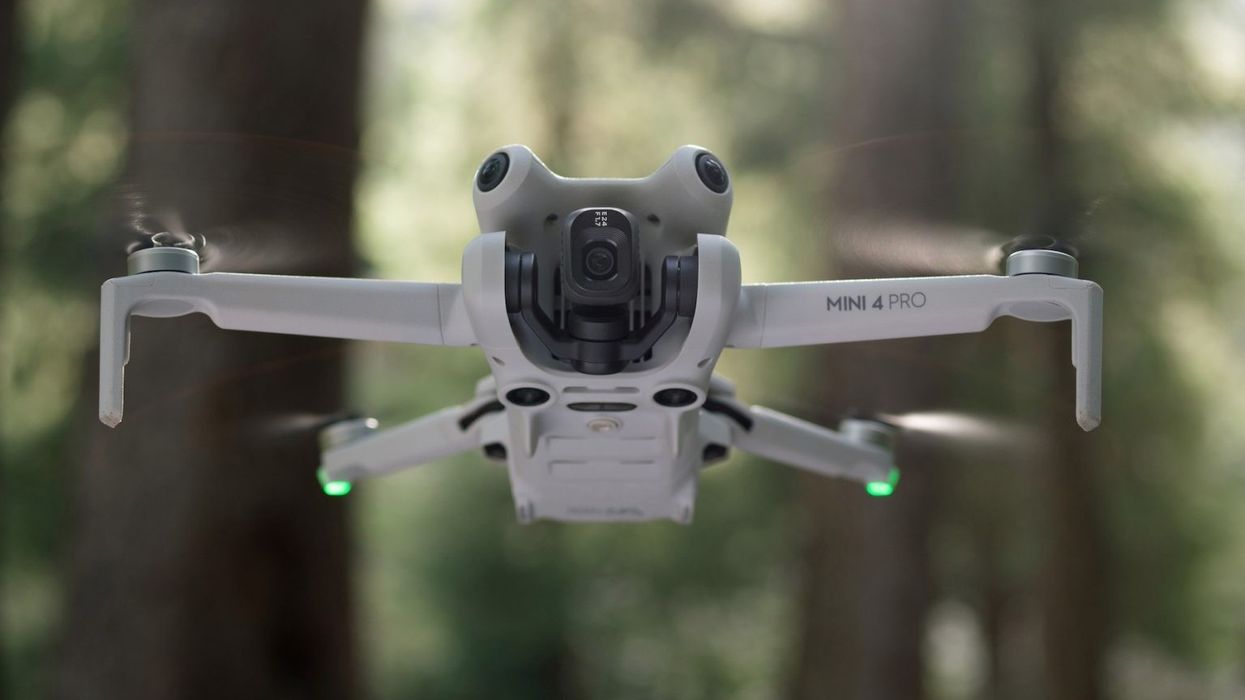
DJI released its latest sub-250 drone that we've seen leak over the last few weeks. Has the hype lived up after flying it for the past week? Are the changes worth upgrading from the Mini 3 Pro that came out less than a year and a half ago? Here's our full review of the DJI Mini 4 Pro.
A drone that wanted to be a 'big boy,' now is
When DJI released the Mini 3 Pro, DroneDJ's publisher, Seth Weintraub, wrote his review for 9to5Mac with the headline: 249g pocket drone plays with the boys boys. While the Mini 3 Pro attempted to bridge the gap between the beginner and professional drones DJI offers, it didn't quite reach. I'm happy to say that the Mini 4 Pro has officially closed whatever gap was left.
The Mini 3 Pro's release was packed full of amazing design changes and innovative additions. DJI has opted to stick with that popular design but build upon where the 3 fell short. Most importantly with obstacle avoidance and recording codecs. However, DJI also snuck in another first for one of it's drones we'll talk about later.
360 Obstacle Avoidance: The blinders are now removed
By far the biggest downfall of the Mini 3 Pro was its "Tri-Directional Obstacle Sensing" that I would describe as "better than nothing." While it provided great peace of mind that you won't smack into a tree when flying backwards, anything to the right or left of the drone was poised to ruin your day if you weren't careful.
One of the first things I did with my Mini 4 Pro when it arrived was flying it right into a tree. No seriously, how else can you test it other than running around a bunch of trees? Turns out it performed perfectly, missing the branches, leaves and picnic table.
DJI's only redesign of the Mini 4 Pro's outside allowed for an upgraded 360 degree obstacle avoidance system and might I say it works pretty well. Not just handling avoiding any collisions but also giving us a more robust ActiveTrack feature.
Called ActiveTrack 360 versus full on Activetrack 4 or 5, it's leaps and bounds better than what the Mini 3 Pro had and works like a charm. I'll say it right here, if your someone that travels and uses ActiveTrack a lot, the Mini 4 Pro is the drone for you.
O4: A truly mini Air 3
The second upgrade the Mini series is getting is the new 04 transmission system announced with the Air 3. Because of this, the Mini 4 Pro will ship the RC 2 or RC-N2 that supports the new system and provides a rock solid, clear transmission feed. I only had hiccups in the feed once while flying and i'm pretty sure I was near some power lines and keep in mind i've been using pre-release software.
Overall however, this drone has felt like flying a much smaller version of the Air 3. From a lot of the same specs to O4, all it's missing is the 3x camera and extra speed. It's a little less stable in higher winds due to weight but it is really similar to it.
D-Log M: All DJI drones in line on consistence color grading
One of the biggest changes in my opinion has been the addition of D-Log M to the list of available codecs for video recording. While before we had 8-bit D-Cinelike, a full 10-bit color option brings the Mini line on par with the other drines.
This is one of those features that is truly for the professionals and not your average pilot. but if you're someone that might have more than one drone working on a project you'll be happy to know all of DJI's series will now record in the same codec.
A pain in my opinion to color grade but I know a lot of you out there want this added and I've been recording in it for anything that might be shared to you in future videos. However, the new HLG format that came to the Mini 4 Pro would be a great option for anyone wanting more out of their video while still preserving the colors.
Accessories: Frustrating ND and wide angle change
Now we'll get into some of the negative sides of the review I have to talk about
Like previous drones before it, the Mini 4 Pro comes with ND and wide angle lens attachment. The ND filter set comes in rather useful ND16, ND64 and ND256. While not exactly tailored to my use cases, that 256 will come in handy for anyone shooting timelapses.
So what's wrong with this? Well while almost the entire drone is the same as the Mini 3 design, DJI changed the mounting system on the Mini 4 Pro for these lens attachments. Meaning you will need all new NDs even though they are most likely the same.
This is most likely due to DJI's push to reduce as much weight as possible. The new hooks for mounting were moved to take advantage of the Mini 4's camera bump. Maybe saving a gram or tw of material at best?
One piece of good news, however, is that Mini 3 batteries are interchangeable between the two drones. Sharing the amazing 30-40 minutes flights flight time, which I got pretty close to with my flights.
Same old camera now very widely in use
Okay, let's talk about this camera and the camera specs that are new with the Mini 4 Pro. While the overall camera is the same that was released with the Mini 3, 1/1.3 24 mm, 2.4µm pixels, and 4K 60fps, it does have some changes, like the addition of 4K 100 fps slow motion.
The most important one is the addition of dual native ISO. A first for DJi to have on one of its drones and in practice it should help you take better photos. now i'm not gonna explain how this technology works, this review is long enough, but the jist is less noise at certain ISO ranges.
In practice, it will be really hard to see those improvements unless you know what you're looking for and to be honest, I don't think I know what i'm looking for. So overall the camera is the exact same but added support for some new video formats. The DNGs that come out of this drone are also great and editing them into some great photos has been a treat.
Mini 4 Pro Image
Final Verdict: Is the Mini 4 Pro worth it?
I think if you're using the Mini 3 Pro right now for any sort of professional video work, then yes this worth the upgrade. If you're big into traveling and using ActiveTrack to capture your adventures, then also yes you should upgrade to the Mini 4 Pro.
However, if you're just a hobbyist that doesn't take advantage of the new video formats, ActiveTrack, or the obstacle avoidance, then the Mini 3 Pro will continue to serve you just fine.
Unmanned aerial vehicles (UAVS), commonly known as drones, have emerged as versatile tools with applications across various sectors. From aerial photograph to disaster response, drones have transformed industries and opened up new possibilities. This article explores the top 20 uses of drones, showcasing how these flying marvels are revolutionizing the world.
Aerial Photograph and Videography
Drones equipped with high-resolution cameras capture breathtaking aerial shots and videos. They're used in filmmaking, real estate marketing, tourism promotion and more.
Agriculture and Precision Farming
Farmers use drones for crop monitoring, pest control, and irrigation management, optimising agricultural practices and increasing yields.
Search and Rescue
Drones aid in locating missing persons or disaster survivors quickly, reaching inaccessible areas and providing vital information to rescuers
Environmental Conservation
Drones monitor wildlife, track poachers, and study ecosystems, contributing to conservation efforts and protecting endangered species.
Construction and Infrastructure Inspection
Construction companies use drone site surveys, progress tracking, and infrastructure inspection, reducing costs and improving safety.
Emergency Response
Drones provide rapid disaster assessment, delivering medical supplies to remote areas, and helping emergency responders plan interventions.
Archaeological Exploration
Archaeologists employ drones to survey historical sites, map ruins, and discover buried treasures, accelerating research.
Geographical Mapping
Drones create detailed 3D maps for urban planning, land surveying, and disaster risk assessment, enhancing spatial analysis. You can analyse the data gathered by the drone on your laptop
Film and Entertainment
Drones capture dynamic shots for movies, TV shows, and sports events, offering unique perspectives and reducing production costs
Wildlife Monitoring
Biologists use drones to study animal behaviour, assess population health, and protect ecosystems from illegal activities
Package Delivery
Companies like Amazon and UPS are testing drone delivery systems, aiming to revolution the logistics industry.
Power line and Pipeline Inspection
Drones inspect power lines and pipelines, detecting faults and facilitating timely maintenance, reducing downtime.
Meteorology and Weather Forecasting
Drones collect data in the atmosphere, improving weather forecasts, hurricane tracking and climate research.
Police departments use drones for surveillance, crowd control, and evidence collection, enhancing public safety.
Ocean and Marine Exploration
Drones explore the oceans, mapping underwater terrain ,studying marine life, and locating shipwrecks.
Infrastructure Repair
Drones perform infrastructure repairs in challenging locations, sucha s bridges, towers and offshore structures.
Oil and Gas Industry
Drones inspect oil rigs, pipelines, and tanks, minimising risks and ensuring safe operations in the energy sector.
Education and Stem Learning
Drones are valuable education tools teaching students about aviation, engineering and technology through hands-on experiences.
Sporting Events
Drones capture dynamic angles in sports broadcasting, enhancing the viewing experience and providing in-depth analysis.
Conclusion
From Transforming Agriculture to aiding disaster response and advancing scientific research, drones have become indispensable in numerous industries. As technology continues to evolve, the applications of drones will only expand, driving innovation and efficiency across the board. The future promises even more exciting possibilities as drones continue to shape our world.
Drone photography is rapidly becoming a mainstay in numerous industries. There are many ways to use drones as you learn how to make money with photography. Real estate is just one of them, where drone-captured aerial views have transformed property showcasing. There’s also the events sector, where drones have revolutionized the way we capture and memorialize special moments, from weddings to large-scale festivals. The tourism industry is another arena where drone photography is making waves, enabling stunning perspectives of travel destinations.
A 2023 study revealed that the global drone services market size was valued at USD 13.9 billion in 2022 and is projected to grow from USD 18.9 billion in 2023 to USD 189.4 billion by 2030.
The Benefits of Starting an Aerial Photography Business
Learning how to start a business surrounding aerial drone photography comes with a host of benefits:
Flexibility: Drone photography offers flexible work hours. You have the freedom to choose your projects and set your schedule.
Demand: As we discussed earlier, the demand for drone photography is skyrocketing in several sectors. You’re stepping into a growth market.
Earning Potential: With the right skills and equipment, drone photography can offer high earnings. A single project can range anywhere from a few hundred to a few thousand dollars.
Are Drone Photography Businesses Profitable?
The potential profitability of a drone photography business is as vast as the skies your drone can reach. As per Skylogic Research, experienced drone photographers can earn over $100,000 per year. However, profitability depends on factors like your skills, the market demand, the type of clients you cater to, and how effectively you market your services.
Challenges in the Drone Photography Business
Even with blue skies and clear horizons, the drone photography business is not without its turbulence. Here are some challenges you might encounter:
Regulatory Issues: Navigating the ever-changing landscape of drone laws and regulations can be daunting. Every country has its own set of rules and regulations regarding drone flight and photography.
Technical Skills: Operating a drone and capturing high-quality photos and videos require specialized skills and training.
Equipment Maintenance: Regular maintenance of drones can be expensive.
Competition: With the increasing popularity of drone photography, the market is becoming competitive. Standing out will require creativity and a keen understanding of the market’s needs.
Key Steps to Start a Drone Photography Business
You’ve fastened your seatbelt, studied the skies, and are now ready to pilot your journey in the drone photography business. But before we take off, here’s a business startup checklist for launching your own drone photography business.
Acquire the Necessary Skills for Flying Drones and Certification for Aerial Photography
Before you can capture stunning aerial shots, you first need to master the art of drone piloting. Here’s how to start:
Learn Drone Piloting: Drone piloting involves understanding flight mechanics and safety measures. There are many online and offline training programs available.
Understand Photography: Learning the principles of good photography is essential. It’s not just about shooting from the sky; you also need to know how to compose a shot.
Get Certified: Depending on your location, you might need a certification or license for aerial drone photography services. For instance, in the Australia, pilots must first their Remote Pilot License, then get their Remotely Piloted Aircraft Operator's Certificate (ReOC).
Setting up Your Business - Legal Considerations and Drone Insurance
Setting up your business involves more than just purchasing a drone. It’s about doing things by the book:
Business Entity: Establish a legal business entity, like an LLC, to protect your assets.
Comply with Regulations: Adhere to CASA regulations or the governing body in your country. Register your drone and always stay updated with the latest rules.
Insurance: Drones are valuable pieces of equipment, and accidents can happen. Insurance protects your investment and gives your clients confidence in your professionalism.
Building a Drone Photography Portfolio and Finding Clients
Now, you’re ready to showcase your skills and attract clients:
Build a Portfolio: Start by capturing diverse shots and showcasing them on your website or platforms like Instagram. Find a niche that appeals to your style, whether you want to use a drone as you learn how to become a wedding photographer or prefer shooting real estate photos. Quality should be your main focus, both in shooting and editing photos.
Find Clients: Networking plays a huge role in finding clients. Attend industry events, reach out to potential clients, and make use of online marketing.
Scaling and Growing Your Drone Photography Business
Expanding your drone photography business? Excellent! But as the sky has no limits, neither should your aspirations. Lets look into strategies to elevate your venture to the next tier.
Investing in Advanced Equipment
Top-tier results require top-tier tools. Investing in superior equipment can enhance your output and make a statement about your commitment to quality.
Upgraded Drones: Consider drones with longer flight times and advanced camera tech.
Gimbal Stabilizers: Ensure smoother video capture, reducing post-shoot editing time.
Advanced Camera Lenses: A varied collection can help achieve different photographic effects and styles.
Diversifying Your Services
Broaden your horizons by offering a diverse set of services:
Videography: Capture moments in motion, which is especially popular for events.
360-Degree Panorama Shots: Offer a holistic view, making locations and properties more immersive.
Building Partnerships and Collaborations
Strengthening your network can lead to steady work:
Event Management Companies: Weddings, corporate events, and festivals can all benefit from drone photography.
Real Estate Firms: Aerial shots can add a unique dimension to property listings.
Marketing and Digital Presence
An online presence is paramount in today’s digital age.
Social Media Marketing: Engage with a wider audience, showcasing your portfolio on platforms like Instagram.
SEO: Boost your website’s ranking on search engines.
Paid Advertising: Target specific demographics with Google Ads or social media promotions.
Email Marketing: Stay in touch with past clients and reach out to potential ones.
Jobs Platform: You can advertise your business and find new clients by joining drone jobs platforms like ours at Drones for Hire! You can visit www.dronesforhire.com.au/signup to join now!
Getting a great Drone Photography Business Website
In the drone photography domain, a picture is worth a thousand clicks. An attractive, user-friendly website serves as a portfolio, a client touchpoint, and a branding tool. Ensure it’s mobile-responsive, easy to navigate, and showcases your work elegantly.
Drone Photography Tips
Diving into the technicalities, here are some game-changer techniques and pointers:
Mastering the Art of Composition in Aerial Photography
Composition is the backbone of captivating visuals.
Rule of Thirds: Break your image into nine equal segments and align the subject with these lines or intersections.
Leading Lines: Use natural lines to lead the eye into the image.
Balance Elements: Balance out your subjects for a harmonious shot.
Understanding the Drone's Camera Settings
Perfect photos require a blend of skill and tech know-how.
ISO: Adjust according to lighting. Lower ISO for daylight and higher for darker scenes.
Shutter Speed: Faster shutter speeds for moving subjects; slower for static or low light scenes.
Aperture: Controls the depth of field. Smaller apertures (bigger f-number) keep more in focus.
Embracing Different Perspectives and Angles
Stunning images often come from unconventional views.
Top-Down Shots: Offers a bird’s-eye view, revealing unique patterns.
Low Angle Flights: Skim close to your subjects for dramatic shots.
Side Profiles: Showcase landscapes or cityscapes in their sprawling glory.
The importance of Planning and Safety Precautions
Well-laid plans lead to well-executed shoots.
Weather Checks: Avoid wind or rain, which might damage equipment or disrupt shoots.
Battery Life: Always ensure a full charge before take-off.
Safety Protocols: Familiarize yourself with local regulations and no-fly zones.
Scaling your drone photography business is a learning, innovation, and dedication journey
Drone farming — it’s a controversial topic that’s gaining traction in the agricultural industry. With the ability to monitor and map forms, assess crops and ensure livestock wellbeing, drones have the potential to revolutionise farming as you know it.
Drone farming is often part of the wider strategy of precision farming, a method that allows you to make better-informed farming decisions. Drones have a variety of use cases within farming — which we’ll discuss later in this article — primarily because they save you time, gather data and offer insights into the productivity, health and profitability of your farm.
Drones used in farming have sensors that can help you monitor your crops and livestock, assess and extract soil data and even offer real-time updates. In short, drones gather important data that can be used to monitor, plan and manage your farm more effectively, saving time and money simultaneously.
Common uses of drones in farming
If your farm predominantly grows crops, then there’s a chance you’re already well-versed in the benefits of drones for precision crop farming as it’s been the primary focus up until now. However, there are additional use cases of drones for you to explore. These include but aren’t limited to:
Mapping and surveying - Using GPS, drones can create 3D maps and survey land and crops so you can accurately view your farm.
Livestock management - Monitor and manage your herd.
Crop monitoring and spraying - Keep an eye on your crops and spray large areas quickly.
Soil analysis - Gather data on the quality of your soil and, as a result, the health of your crops.
Irrigation - Drones use thermal sensors to determine which farmland areas need more or less water.
Improving sustainability - Fewer emissions than traditional machinery and greater accuracy.
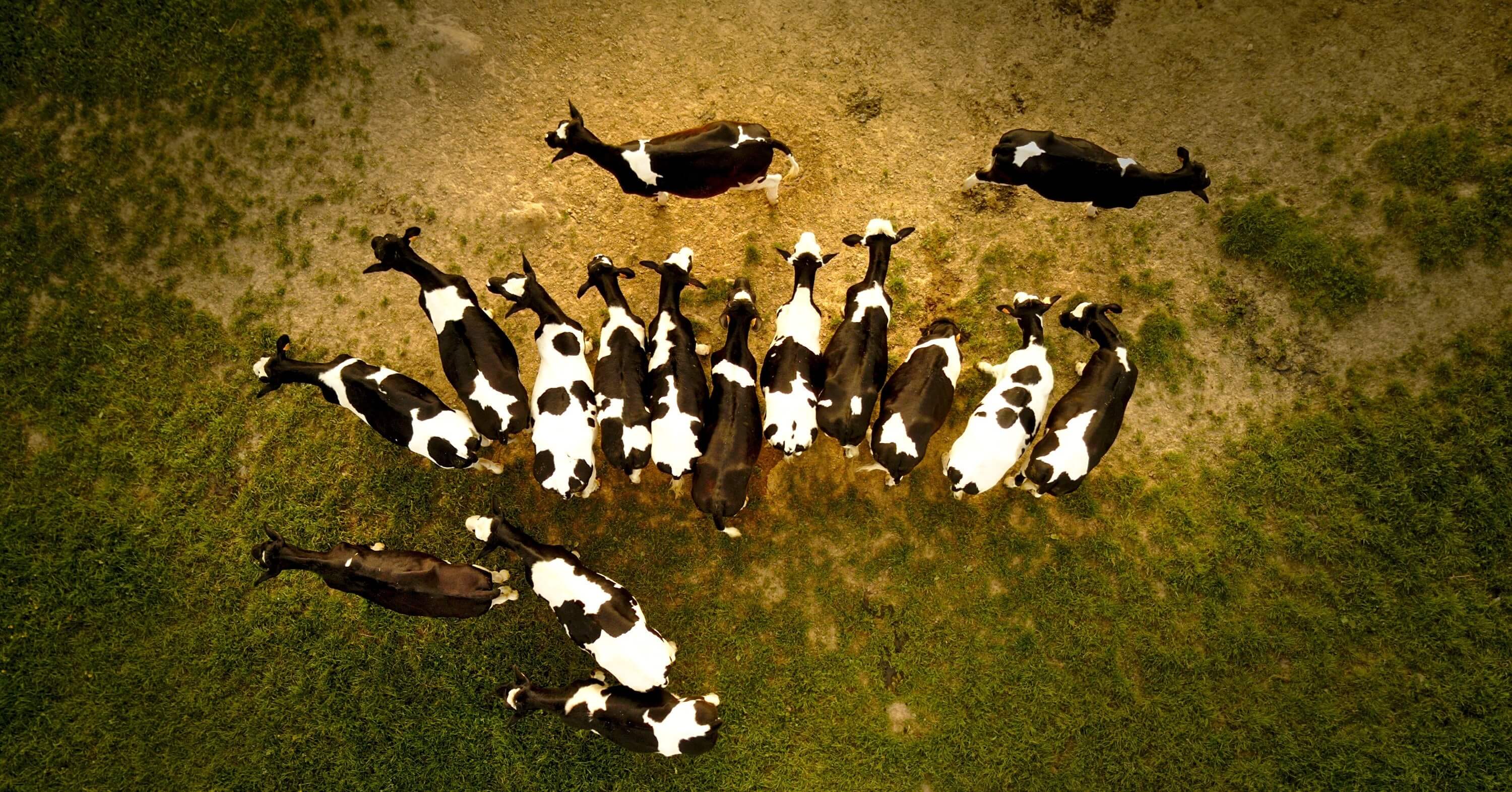
Drones for cattle: A new use on the horizon
Farmers are increasingly harnessing the power of drones to help monitor and assess their livestock. No matter the size of your herd or the land you farm, monitoring your cattle's health and wellbeing can take time and effort. That’s where drones come in.
A drone’s activity can then be translated into data, a driving force in modern farming. This data can help you plan, make better-informed decisions and ensure your farm's productivity, efficiency and safety.
So what’s the result? Automation of time-consuming tasks — you can better spend your time elsewhere. Greater accuracy — reduced risk. More efficiency and productivity — fewer costs. Drones can save you time and money while increasing productivity, efficiency and, ultimately, profitability.
Will drone farming take off in the future?
As the digital revolution continues, the need for sustainability grows and farmers are tasked with doing more with less. Drones can be a wise investment for your farm.
As time progresses and more farmers invest, the quality and performance of drones will increase. There’s already talk of pairing drones with AI software to automatically analyse the data they gather, saving you another task and making better use of your time.
But as with any new technology, there are often limitations to consider. Perhaps the biggest issue is resistance to change. As is often the case with new technologies, there are few past experiences and general knowledge about drones.
In addition, although drones ensure a high level of accuracy, they aren’t guaranteed to give exact results every time, so they may still require human intervention. Finally, drones are expensive, meaning they won’t be accessible to all farmers.
Even though these limitations exist, it's possible to say the benefits far outweigh the risks.
Profitability matters
We know that profitability will be one of your main priorities. For more information, insights and articles, head to our profitability page where you can find out all the latest.
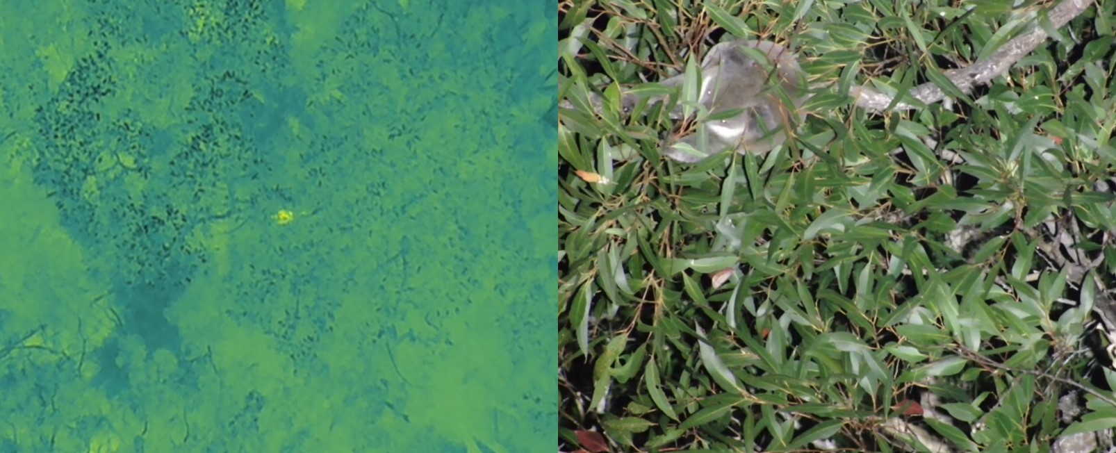
Conservation scientists from the University of Newcastle are using heat-detecting drones to capture data on koala populations in Port Stephens LGA.
More than 130 survey sites in Port Stephens LGA will be studied. Over the next few months, e ach site will be surveyed three consecutive times to accommodate variables and capture an accurate picture of the koala population.
Using the data from the survey sites, scientists will be able to create a model to better predict koala numbers across vast landscape. The thermal drone technology is also able to detect other species including wallabies, possums and gliders.
Camouflaged in tall treetops, koalas are notoriously difficult to detect. Traditional methods such as acoustic recordings to identify koala calls or spotlighting with head torches are labour intensive, costly and limited in accuracy.
Research leads, Dr Ryan Witt and PhD candidate Shelby Ryan from the University of Newcastle said drones are a cheaper and more efficient way to find koalas. In a previous study, Dr Witt and his team searched a particular location on foot at night with spotlights and found on average one koala every seven hours. When searching the same location using thermal drones, the team found an average of one koala every two hours.
The data will provide clues on how to best manage koala populations. Early data from surveys so far has revealed a concerning absence of koalas in the Tomaree Peninsula area, with the population localised to just one area.
The research team is inviting private landowners of large blocks in Port Stephens to get in touch to discuss the potential for their land to be surveyed as part of this study. Please email ryan.witt@newcastle.edu.au.
This project is delivered in partnership with FAUNA Research Alliance, Taronga Conservation Society Australia, Hunter Water Corporation, WWF-Australia, and Port Stephens Council who received grant funding from the Australian Government.